Open IMINT uncovers Chinese miniature landscape
Google Maps is quite a revolution in Open Source Intelligence, as it provides access for ordinary people to rather good satelite imagery.
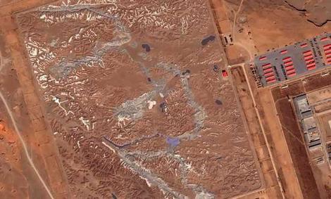
A good example is a Google Earth community that has uncovered a strange sight in China. The Chinese have created a miniature landscape, including mountains, rivers and roads. Alledgedly it is modelled over a piece of disputed territory between India and China.
It is a known fact that the (US) military can make Google cover sensitive areas with wood or otherwise on the pictures. Never the less you can still find a lot of military and corporate sites using the service.
posted by Nis at 27.7.06
![]()


2 Comments:
"You can still find a lot of military and corporate sites using the service."
yes,
but most of that information is 'stale', no?
2/8/06 02:11
Well yes, that is true. However to some ends you don't need a hour-fresh picture, for example to find coordinates and a general overview of buildings, roads etc.
2/8/06 06:36
Post a Comment
<< Home